


Vizsla Silver Drills 1,030 G/t Ageq Over 20.45 Metres At Copala - Expands Mineralized Zone To 600m By 400m


Receive up-to-date information about the company directly via push notification
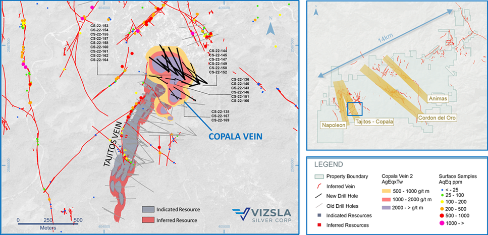
Vancouver, British Columbia (June 21 , 2022) – Vizsla Silver Corp. (TSX-V: VZLA) (NYSE: VZLA) (Frankfurt: 0G3) (“Vizsla” or the “Company” - https://www.commodity-tv.com/ondemand/companies/profil/vizsla-silver-corp/ ) is pleased to report results from 24 new drill holes targeting the Tajitos - Copala resource area in the western portion of its 100%-owned, flagship Panuco silver-gold project ("Panuco" or the "Project") located in Mexico. The results are exclusively for the Copala structure and expand the high-grade mineralized footprint to 600 metres along strike by 400 metres down dip.
Highlights
- CS-22-169 returned 1,030 grams per tonne (g/t) silver equivalent (AgEq) over 45 metres true width (mTW) (780 g/t silver and 4.23 g/t gold)
- Includes 2,727 g/t AgEq over 1.21 mTW (2,230 g/t silver and 9.08 g/t gold)
- And 9,880 g/t AgEq over 0.85 mTW (7,900 g/t silver and 35.20 g/t gold)
- CS-22-155 returned 900 g/t AgEq over 14.50 mTW (667 g/t silver and 3.89 g/t gold)
- CS-22-154 returned 1,331 g/t AgEq over 9.35 mTW (1,010 g/t silver and 5.44 g/t gold)
- Includes 4,579 g/t AgEq over 1.30 mTW (3,548 g/t silver and 17.78 g/t gold)
- CS-22-164 returned 1,242 g/t AgEq over 4.40 mTW (802 g/t silver and 6.89 g/t gold)
- CS-22-160 returned 2,007 g/t AgEq over 3.40 mTW (1,642 g/t silver and 6.67 g/t gold)
“The Copala Vein continues to exceed our expectations, delivering excellent precious metal grades over very large widths,” commented Michael Konnert, President and CEO. “When we first discovered the Copala Vein in late 2021, we knew we were on to something special given the well developed, near surface mineral continuity. At the time of the maiden resource, eight drill holes from Copala contributed 6.4Moz AgEq of indicated and 18.6Moz AgEq of inferred1. We have now reported 46 holes from Copala, effectively expanding the mineralized footprint to 600m along strike by 400m down dip with drill intercepts showing mineralization remains open in all directions. We continue to target the Copala area with three rigs and view this portion of the district as a major focus for resource expansion ahead of the Resource Update planned for Q4 of this year.”
1 See details of mineral resource estimate in the “About Panuco Project” section, below.
Figure 1: Plan map of recent drilling centered on the Copala vein.
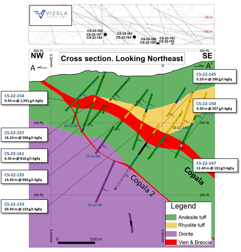
The Copala Vein is a shallow dipping structure located at the northern extent and on the hangingwall side of the Tajitos structure. Copala is marked by high precious metals grades (up to 7,900 g/t silver and 35.20 g/t gold over 0.85 mTW) hosted within a broader envelope of vein-breccia up to 82 metres thick with local mineralized pockets up to 20.45 mTW averaging 1,030 g/t AgEq (780 g/t silver and 4.23 g/t gold).
Today’s reported intercepts expand a NNW-SSE striking high-grade shoot with approximate dimensions of 400 metres along strike and 200 metres down dip. This high-grade zone remains open to the north and down-dip to the east. Ongoing detailed structural-geologic interpretations suggest mineralization continues to the south, beyond the previously reported Cristiano Vein (see press releases dated January 19, 2022 and March 10, 2022), and is a near-term focus for expansion as Vizsla continues to explore this area. The Company currently has three drill rigs targeting the Tajitos – Copala resource area.
The Company is encouraged that the northern sector of the Tajitos – Copala resource area continues to grow, and the intercepts reported here, along with the recent discovery of Copala 2 between Tajitos and Copala (see press release dated May 19, 2022), demonstrates significant potential for additional blind to surface veins in the district. Vizsla is currently negotiating additional land access and has prepared a drill plan to advance the exploration of the Tajitos - Copala area to the north. To further support its 2022 growth initiatives, Vizsla recently completed a district-scale LiDar survey over the main 6,200 ha claim block to aid in geologic-structural mapping, drill-hole planning and geologic modelling.
Figure 2: Plan map of Copala vein with drill-hole pierce points.
Figure 3: Cross section showing Copala and Copala 2 veins.

